About six months ago, Pete’s Dad and family proposed the idea of taking a trip out to the Grand Canyon. I, naturally, was all in.
The initial plan was to head out to the South Rim, spend the night; bus over to the North Rim, spend the night; hike down the North Kaibab Trail to Phantom Ranch, spend the night in the canyon; hike out via the Bright Angel Canyon and head home. I, of course, saw an opportunity at hand.
I told the crew that I would forego the bus trip in exchange for running the canyon instead. After being called crazy in several different ways, I began my limited research of running the canyon. Okay, I have to admit, I didn’t do much research. With all the races and events I have planned for this Summer, I was really treating the canyon as an experience. And it’s probably a good thing I did.
Here are some stats on the Grandest of Canyons:
- Average depth: 1 mile
- Rim elevations: south rim, 7,000′; north rim, 8,000′
- Average temperature in the canyon in June/July: 106 degrees
- Bright Angel Trail: 9.3 miles; 4,380′ descent to the Colorado River; average grade of 10%
- North Kaibab Trail: 13.7 miles, 5,660′ ascent from the Colorado River
- River Trail: 2 miles connecting the Bright Angel Trail and North Kaibab Trail
According to the book Over the Edge: Death in Grand Canyon:
“Once one descends even ten feet below either rim of Grand Canyon, one has entered a new and different world. This world is the most convoluted, massive, and jaggedly vertical landscape on Earth, a vast complicated labyrinth carved by the vagaries of erosion as it removed 1,000 cubic miles of rock in a dendritic drainage pattern that gnaws into bedrock cliffs thousand of feet high and fractures the landscape into 600 tributary canyons. The vast majority of rock surface here is so nearly impossible to access that it may never be visited by humans. The few practical routes penetrating this landscape – most of which were pioneered millenia ago by Native Americans – are themselves fraught with precipices and pitfalls and decaying sedimentary rock that weed out the unwary.”
According to the limited research I did prior to the trip, the biggest concerns I had were the heat, water availability, and honestly, the magnitude of it all. Everyone I talked to about running R2R warned me of the myriad risks.
When we arrived at the South Rim on Friday, Pete pretty much summed up everything I was thinking: “wow, this just got real.” No joke, if you’ve ever been to the Grand Canyon before you’ll understand. Standing at the brink of the canyon makes you feel just how small you actually are. All I could think of was “holy crap, I’m going down THERE?”
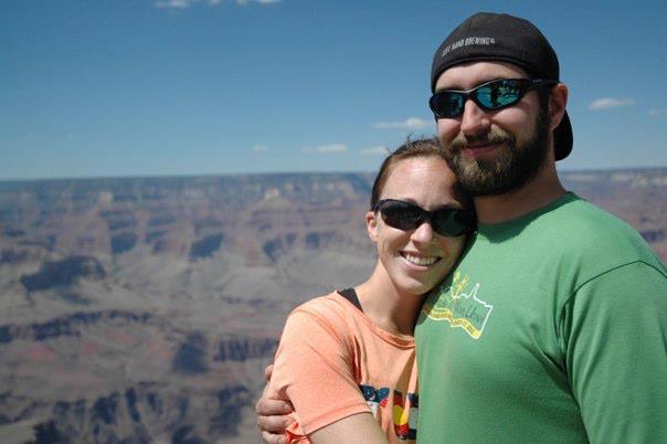
Pete & Me on the South Rim

Grand Canyon view from the South Rim
Here’s how I’ll sum up running the Grand Canyon: it’s like running/hiking an inverted 14er on steroids.
Elevation profile of South Rim to North Rim
My friend Christie that was a part of our GC crew (aka the Crazy Eights) decided she was going to make an attempt at the R2R as well. Not exactly a runner, Christie’s goal was simply to make it.

Christie “Red Zeppelin” Stevens – she’s a badass
After my alarm sounded at 3:30, I received a call from Christie – she had made it less than a mile down the trail before being “cornered” by an unidentified cat. Amanda to the rescue! After an uneventful reuniting with Christie, we decided to stick together while it was still dark out. After a couple more miles of dodging mule poop by headlamps, Christie and I turned a corner when I heard a rustle near us in the bushes on the trail. My instinct came in and I yelled loudly (like encore-loud) towards the noise: “HEY YOU!!” I immediately realize that I had just yelled at a middle-aged woman. Perfect. At least I have keen cougar senses.

Sunrise on the Bright Angel Trail
The rest of the run up until Phantom Ranch at 11 miles was relatively uneventful. We hadn’t hit direct sunlight yet and the trail was mostly downhill. Here is the folcrum in the adventure: after Phantom the trail levels out through a slot canyon and eventually begins climbing towards the North Rim. Christie and I stuck together for a few more miles until I eventually pulled away.
The rest of the run/hike was hot and steep. While the elevation wasn’t bothering me, the terrain was definitely different. It was sandy in parts and packed in others. Add in the fact that my quads were already sore from the initial descent and the weight of my pack (I was carrying a 100 liter blatter, 2 additional water bottles with electrolyte-enhanced water and a bunch of bars and gu’s), I was definitely feeling some fatigue.
Here’s what I used for nutrition:
Peter Rabbit Organics Baby Food
Nature’s Bakery Fig Bars
Mini Clif Bars
Clif Shot Bloks
Cheddar Chex Mix
I reached the North Rim later than anticipated, most likely due to being pretty careful to not injure/exhaust myself on day 1. I headed to the North Rim Grand Lodge and enjoyed one of the best tasting and satisfactory beers I’ve had in a long time, overlooking the expanse of Canyon I had just conquered.

A delicious Hefe on the North Rim
After meeting up with the rest of the crew (including Christie – congrats!) and enjoying a nice dinner and incredible sunset, we all hit the hay early to prepare for our 2-day mission starting promptly at 5:00am.
We made our way down the North Kaibab Trail and man, were my quads SCREAMING at me! I’ve never wanted some flat or uphill that badly before! To make matters even worse, about 8 miles into our 14 mile hike, it started heating up. It was 112 degrees in the SHADE. It sincerely felt like we were in an oven. By the time we hit Phantom Ranch at 14 miles, we were all out of water.
It’s funny how the small things can mean so much at times of extreme fatigue. I’ve never enjoyed a glass of ice cold lemonade more than after that hike. What’s more, we all got into Bright Angel Creek to cool off. The water was so clear and refreshing!
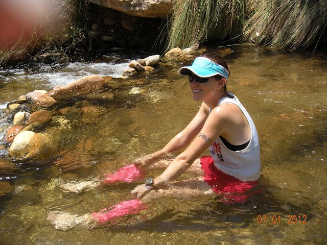
Bright Angel Creek
The cool part about Phantom Ranch is its exclusivity. Less than 1% of those that visit the Grand Canyon make it down to Phantom Ranch. Yes, you have your mule riders and rafters, but everyone is there with at least one mutual appreciation.
Here’s a quote hanging on the wall at the canteen at Phantom Ranch:
“Where tranquil trails, turbulent streams, mountain monuments and deep ravines; wind and turn, rise and fall, God knows best how he made them all – rugged lands of the West.”

Quote on the canteen wall at Phantom Ranch
After a family-style meal and a sweet glass of wine, we headed to our respective dormitories and zonked out. The next morning, we woke up bright and early, ate some breakfast at the canteen, and headed out to the South Rim. With 11 miles in front of us, most of which were uphill, I was actually looking forward to it.
After a couple miles along the River Trail we hit the Colorado River – this is where the ascent officially begins. Unfortunately, one of our crew members was having issues with his knee. Unwilling to quit, he bid us to go ahead at our own pace. Several stayed back to ensure he made it (which he did!), and I decided to take advantage of the uphill terrain and high spirits.
I kicked it into fifth gear and sped up those last 9 miles. Whether it was the training or my experience of climbing/hiking in Colorado, I seriously OWNED that ascent. I’m a relatively humble person, but I’m damn proud of how fast I made it up the South Rim. The only negative thing I have to say about that ascent was all the complete douche-bag tourists hiking about 2 miles from the rim. Not only do they not know trail etiquette, but they appear to not be very bright either. Seriously, there were families 2 miles down with empty water bottles, people wearing flip flops and kids playing too close to the edge. Food for thought: if you start seeing purses and jeans on the trail, watch out.
It was almost 4 hours before I saw a few others (including Pete!) of our crew. We hit the saloon at the Bright Angel Lodge for a congratulatory beverage.
Stats from the 3-day R2R2R:
- 51 total miles
- Elevation gain: 10,301′
- Elevation loss: 10,301′
- Total elevation gain/loss: 20,602′
- Coldest temperature: 48 degrees on the North Rim
- Warmest temperature: 112 degrees in the canyon in the SHADE
- Number of hours: approximately 20
I can’t say how amazing this trip was. From the R2R, to the fun times with our crew, to learning about how intense the Grand Canyon really is, I’m already ready to go back. Seriously. Now that I know what to expect and the magnitude of it all, I’m ready to attempt a R2R2R on my own – in one try.
I didn’t take a lot of pictures on the trip, but some of our crew did. Below are just a few I snapped, but I’ll post some more later!

Three of the Crazy Eights

South Rim

Deer outside the lodge – totally normal
Up next: Leadville Silver Rush 50 Miler on July 15th with Ben.

Awesome accomplishment! Love the tingly ‘cougar’ senses haha. Sounds like a fun trip.
Wow! You can’t see it, but I am bowing in reverence for your accomplishment. You social media folks rock!!!
Pingback: Facts of Grand Canyon Formation « Life is Mysterious
Pingback: Adventures in Trainingland | When it's all said and RUN